John Willard, owner of The Birches, helped create the NFCT and always cheers me on with my paddling adventures. If you ever visit, be sure to go up for a float plane ride with John and see where you have (or will) paddle from the clouds.
One luxury of through-paddling is working off what you eat, even when it is a stuffed omelette, English muffin and jelly, and The Birches “small” orange juice, which is not small. Mom waved farewell to the rest of us after breakfast. Dad would paddle the seven miles around Farm Island and Sue and I were headed to a beautiful cove where we had camped before, an easy day. Easy, that is, as long as you arrive before the wind gets up and find an empty campsite.
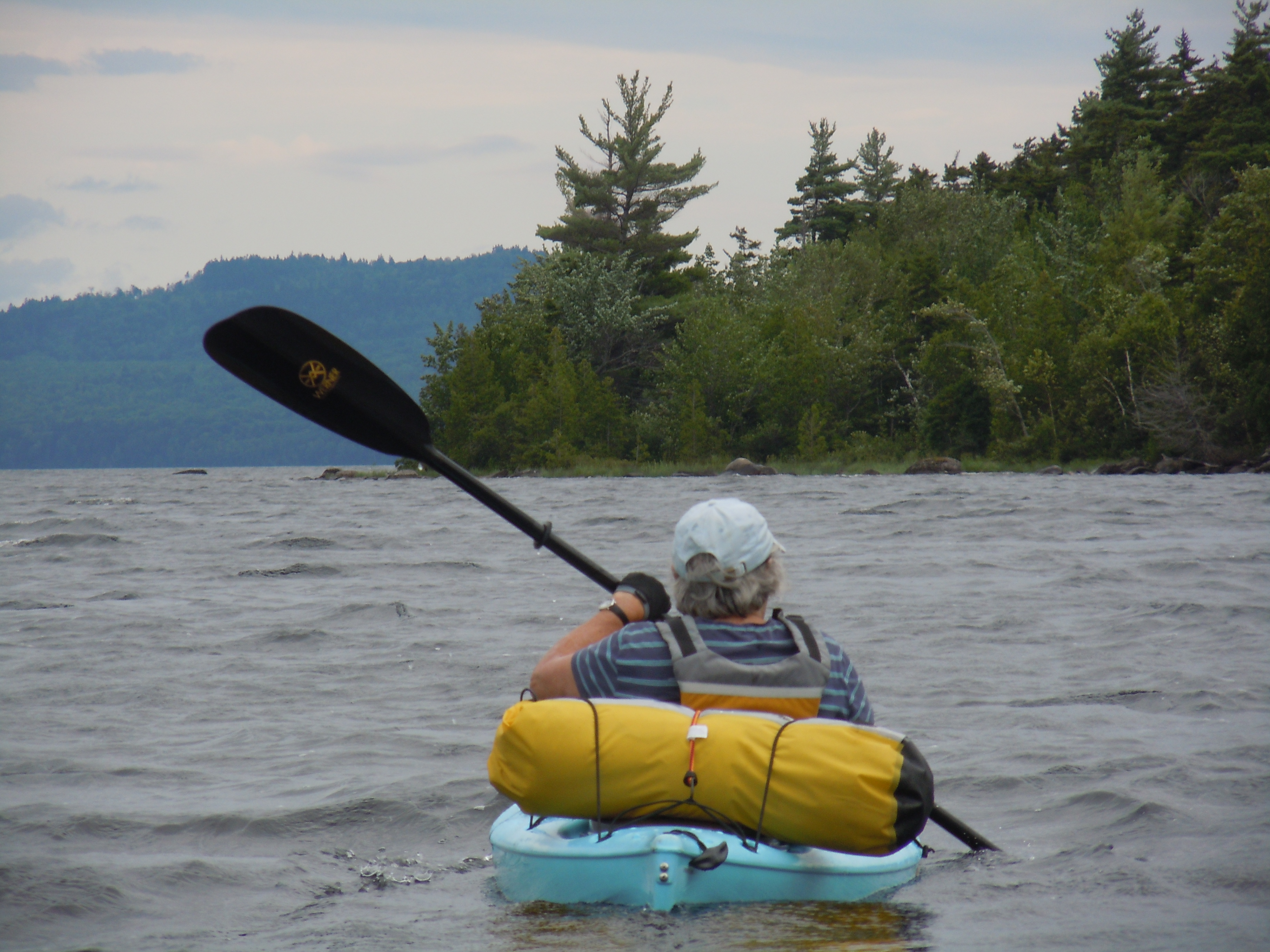
My aunt, Susan Sefcik, shares my love of the outdoors and, like me, has been venturing out on some solo trips. She joined me for the miles on Moosehead Lake, camping in Big Duck Cove, then stayed for a few extra days, braving some hearty winds along the way.
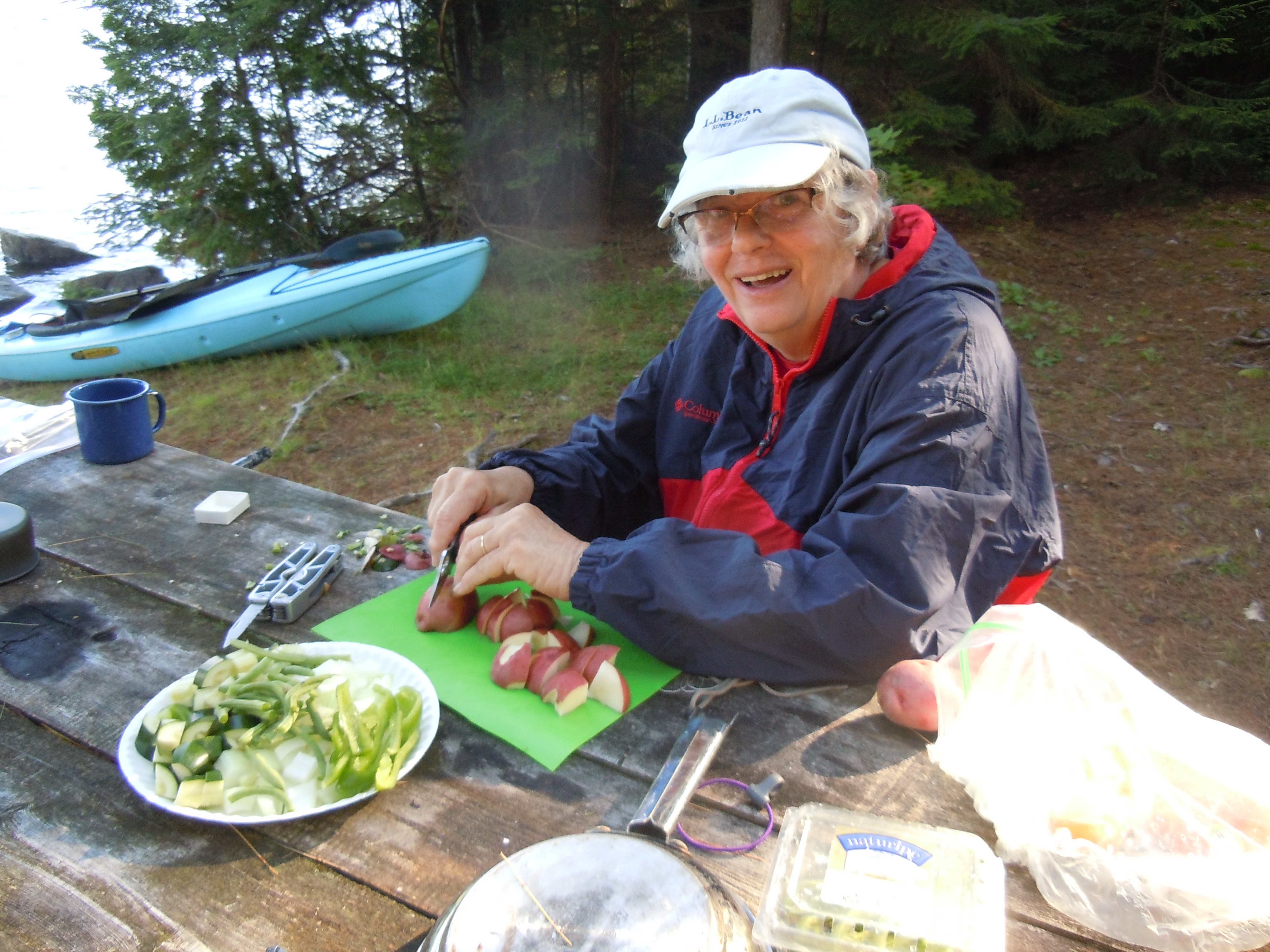
Paddling strong, we made good time, to discover one of our two favorite back-to-back sites free. We were on the protected back side, helpful indeed when the wind blew whitecaps down the length of the cove later that afternoon. Lazy hours in camp to gather wood, watch a red squirrel scamper past our tents with a furry bundle of baby in her mouth, then dabble our feet at water’s edge with a crayfish and minnows for company. It was a bit cold for swimming, though, and we were glad to layer up after a quick dip. Family togetherness in the great outdoors!
Sue loves to cook and I love to eat…with my appetite being especially well-developed at the moment. Dinner was turkey stir-fry with a multitude of fresh vegetables and the anticipation of pancakes and bacon tomorrow morning.I love to cut firewood and Sue loves campfires…here is our tidy camp on the cove.
On Tuesday, August 11, I paddled into Fort Kent on the St. John River, completing my solo through-paddle of the Northern Forest Canoe Trail in 53 days.
Yesterday, after a long (30.8 miles) and damp day, Dad and I passed under the international bridge on the St. John, reaching the eastern end of the NFCT. My GPS total reflected 749.7 miles. With God’s grace, I had covered every mile unassisted. It felt unbelievable.
I think my numb, white fingers and shivering self tempered some of the emotion of the moment, but I still felt ready to cry. So many days of beauty, danger, kindness, and endurance were coming to an end. A dream, that once seemed beyond all reach, would now become a treasured memory.
To all of you, who cheered me on and supported me in infinite ways, please know that you were with me in that special moment and you will always be part of the story of NFCT 2015 for me!
(I hope to write up the rest of the days, with many photos, while it is all fresh in my mind).
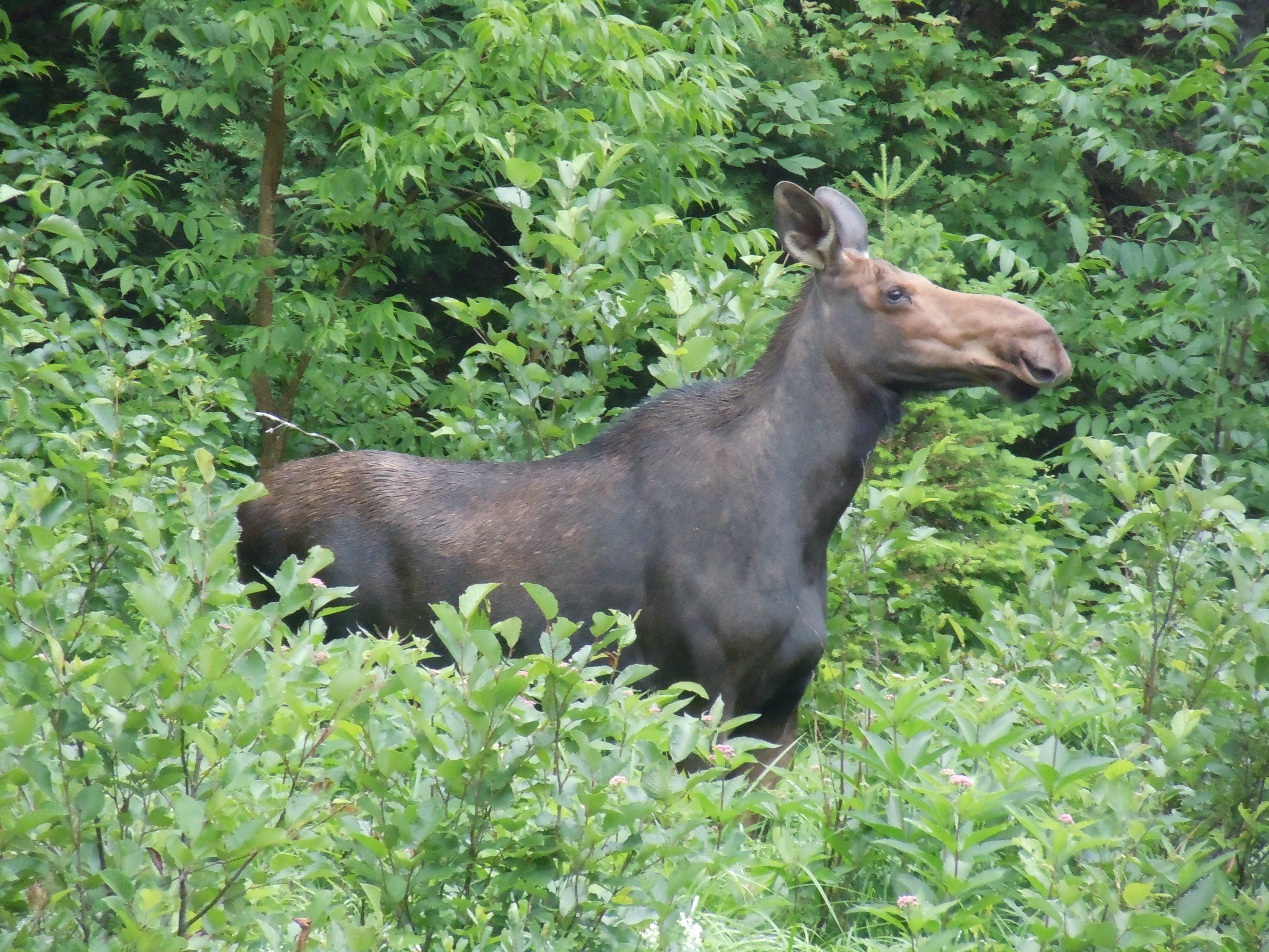
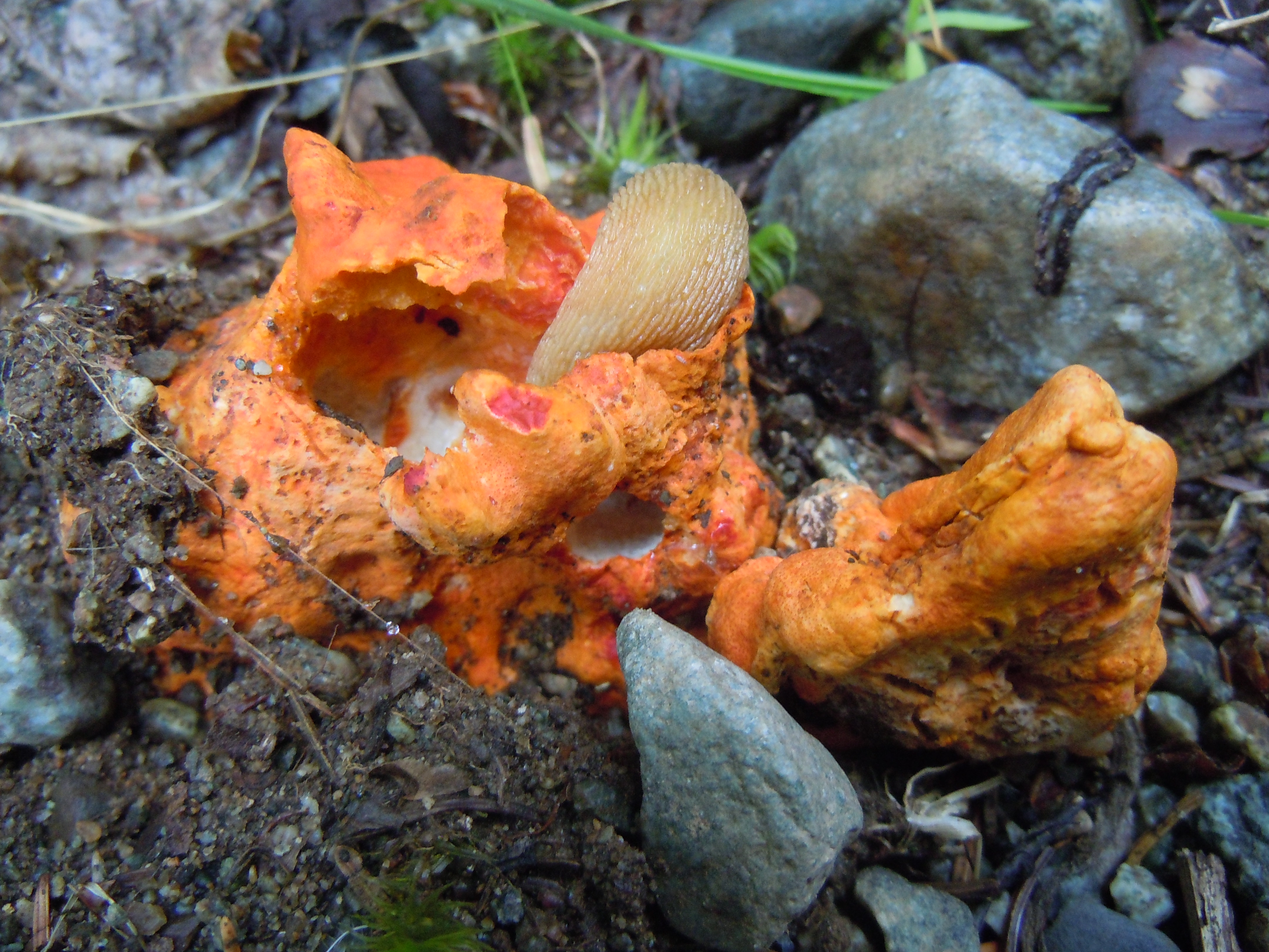
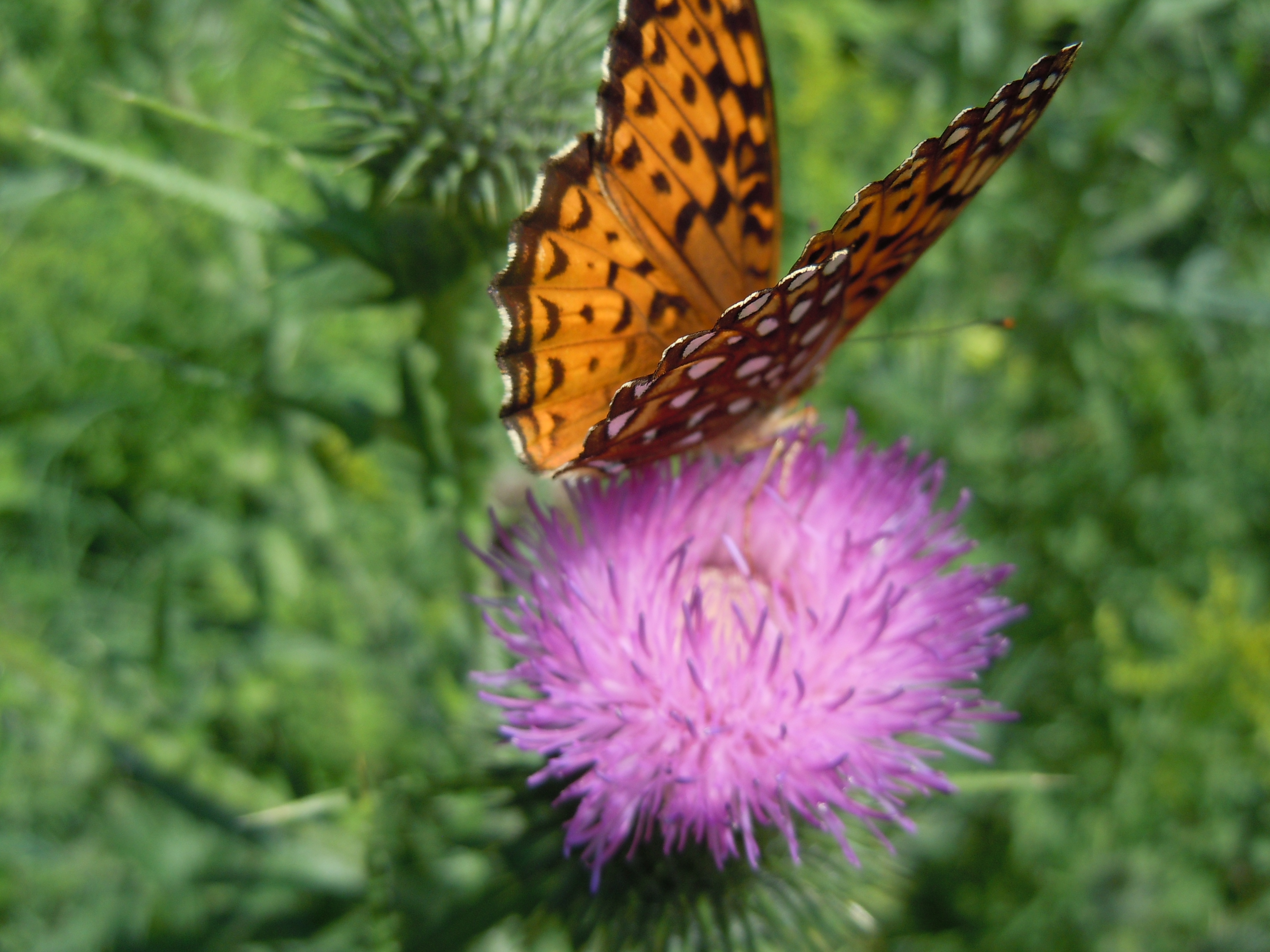
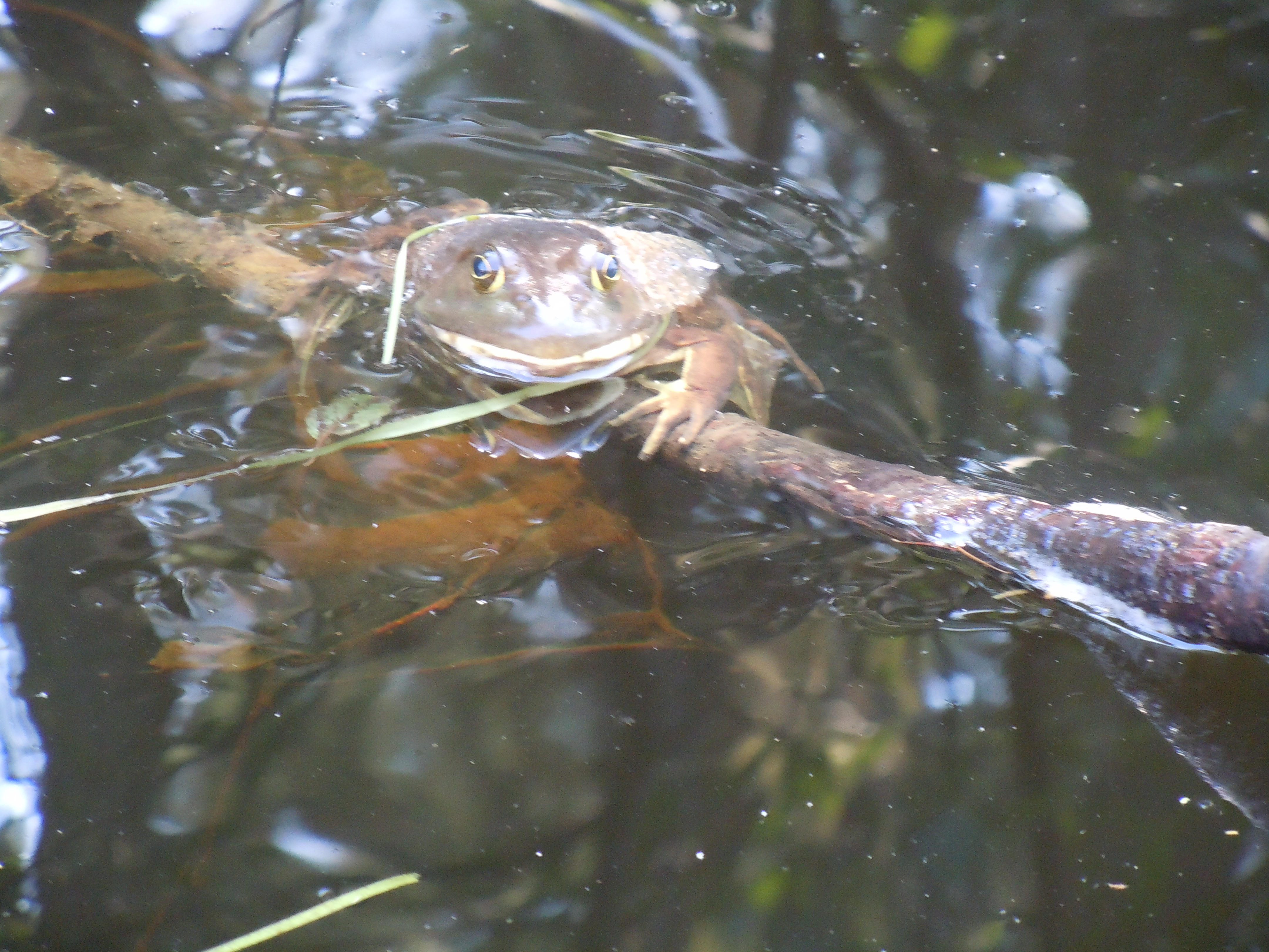
First moose of the trip…we enjoyed each other while I ate my scrumptious no-bake cookie on Little Spencer StreamCanada lilies continue to glorify the river banksFascinating fungus being devoured by a slugFlower of the day…quite small…found in wetter areas…Allegheny Monkey Flower, says Chris Gill, one that I know I never discovered before…thanks!Butterflies were in abundance during the Hardscrabble Road portageLaid back frog hanging out along the Moose River
Wow, I am blogging from my tent as dusk falls, determined to post this before it gets dark. This week I’ve had many long, tough days and my body is begging for a rest. Again this afternoon, I was digging deep to keep paddling until I reached camp.
The day began with bright sunshine as I finished Long Pond, paddled a short section of the Moose River and then tackled the almost four-mile Demo Rd. portage to reach Little Brassua and Brassua Lakes and my island camp.
It was hot enough mid-morning to go for a swim from this island near the end of Long Pond.This two miles of the Moose River had four fun rapids, the most challenging I’ve run with my new canoe, and a moose in a cove at the third one, where there was no hope of stopping.
A highlight was discovering the same composition book journal here on the island. It has survived seven long Maine winters and still has some of my Paddle for Hope business cards tucked in it!
(Just discovered that I have four bars on my phone and can actually blog from the trail, my original hope for my trail writing. It is now tomorrow!)
So, it was another five miles into Jackman, which I could not have endured last night. So good decision to stop and camp.
This morning, paddling into town went easily and I was grateful for no float plane traffic on Big Wood Pond, just a couple of planes tied up near the Jackman Landing Campground, where I took advantage of their nice laundry. Then on to my favorite Jackman restaurant, Mama Bear’s for a turkey BLT, fries, brownie sundae, and some writing.
The seven-mile stretch of the Moose River out of Jackman is a relaxing paddle. I saw a deer, that snorted as I was drifting and reading my map, and also was very unobservant in not noticing a giant deadfall tree full of ospreys until after they took flight! That was just as I entered Long Pond from the river (below).
Tonight is what camping should be. This was my third time trying to camp in this site on the Lower Narrows of Long Pond and I made it. On the 2006 Map 10, it is in the wrong location, but this time I knew right where to head.
Sunset from the campsite beach, where there was a bench by the fire and I lingered until after dark eating all the fresh food from my grocery store run and listening to the loons. Later, I even had a glimpse of the moon, which has recently been obscured by all these cloudy mights.
TOTAL MILES: 550.8
There is magic in the feel of a paddle and the movement of a canoe, a magic compounded of distance, adventure, solitude, and peace…Sigurd Olson
Thank you, Nancy and Arne Aho, for inspiring me with words from an author who was surely a kindred spirit, Sigurd Olson. Someday I will paddle the lands of which he writes so vividly.
Mary sent me off well fed and with enough food for the day, especially simple foods I had been craving, like yogurt, hard-boiled eggs, and carrots. It was nice to have someone wave me off, as I paddled from the White Wolf Inn through a creek and into the lake.
The cadence of my paddle, grandeur of the Bigelows marching along the water, the warring weather, with mist and rain the victor, all combined to put me in a poetic mood. There is a poem simmering inside me about this day, just waiting to be finished.
Marji and Sydney passed me, the first time I’d seen them since the Rapid River. Well, they indeed got rescued in grand style, staying two days in a yurt and visiting with Aldro French! Their new wheels arrived and are serving them well.
I ate lunch on Hurricane Island, where I thought nostalgically of the note that Timm and Sal had left for me there during Paddle for Hope. Today the island has a newer journal that only goes back to 2013. Sydney, Marji, and I all put in a lot of miles with the wind at our backs…18 miles to the last campsite on an island in Flagstaff Lake. Other than noting the serenading of many loons, I journaled little, had yogurt for supper, read a bit, and fell asleep wicked early!
It’s rather a long walk from the Kennebago Rd. bridge to the town of Stratton for everyone, due to difficult rapids even when water levels are high. Thankfully, the miles flew by, mostly downhill with comfortable temperatures and interesting sights.
The Coplin Plantation Schoolhouse, circa 1845, sits on a great stone foundation.
Next a raccoon, which joins whitetail deer, red and gray squirrel, beaver, mink, chipmunk, otter, and gray fox on my mammal list for this trip, so far.
Dramatic skies have been a daily companion, keeping me guessing about the weather. Later in the evening, we had a massive downpour.
Ralph, whose son at SMU is doing a summer project about the NFCT, visited with me coming and going to town to get the morning paper. Ralph also met Mack Truax on his through-paddle…it was someone walking a sea kayak…must have been Mack!
Here’s what the kiosk in Stratton has to say about the South Branch of the Dead River…perhaps I was helped by the thunderstorms passing through.
So, my day of paddling (let me change that to walking) ended in time for lunch at the White Wolf Inn. A leisurely and delicious grilled chicken sandwich with fries and pecan pie while I did my writing.
The kind folks there, who are so welcoming to AT hikers, too, willingly stored my boat overnight while I relaxed at Sugarloaf, thanks to Mary Berger. Mary worked out her always-busy schedule to whisk me away for an evening of hot tubs, bathrobes, and soft beds. An added bonus was a surprise chance to visit with most of our wonderful GSB bus drivers, who were there for a meeting.
I AM SO BUMMED I FORGOT TO TAKE A PICTURE OF YOU ALL..if someone took one of you having dinner at The Rack I could insert it here!
I love this photo…between the hot tub and visiting with Mary, body and spirit are rested and renewed!
TOTAL MILES: 475.0
I believe Janie and Paul could actually fatten me up while I was paddling and portaging long distances every day. Today, homemade waffles to begin what I knew would be a challenging day.
Gave Noah (taking photo) and NFCT interns Matt and Evan a huge thanks for their hard work and the promise to return sometime to help with a work trip.
Noah encouraged me to paddle some today. What’s unusual about that? Typically, this time of the summer, the South Branch of the Dead River is dead (water too low for paddling). And not knowing, many through-paddlers do not attempt any of this section, instead taking a shuttle or walking 23 miles! I had my heart set on at least trying and then sharing the results with other paddlers.
PADDLER’S NOTE: I successfully (with some effort) paddled about 9 miles of the South Branch of the Dead River. Walking to the Dallas Carry put-in from the museum was 3.5, not 2.5, miles.
From Dallas Carry to the Fansanger Falls portage was 2.4 miles, including parts like the Nulhegan and parts like the deeper Clyde. Obstacles included over and under a couple of fallen trees, Class I rapids that were also shallow, and out of boat for perhaps 8 boulder gardens, worse near end. This section took 1.5 hours.
Today’s flower identification puzzle…thanks to Chris Gill and Janet Dempsey for supplying the name of Swamp Candle, which I also saw in profusion today.
Wouldn’t it have been sad to walk by this?
PADDLER’S NOTE: Some kayakers thought I could put in at the bridge a mile before the Langtown Mill bridge, but there was a large fishing audience, steep bank, and I continued walking.
The 6.7 miles from the Langtown Mill bridge to the Kennebago Rd. bridge gets deeper, calmer, and less rocky as you progress. The first three miles included a huge tree across the river that required a actual portage; fast, sweeping turns with strainers; some fun rapids; and at least a dozen times out of the canoe walking.
The day ended excellently with a perfectly-mown stealth campsite complete with approximately 10,000 black flies and mosquitoes. I cooked and ate my burritos from the tent.
Another great Cup o’ Tea tradition is signing the wooden steps, which still bear the marks of Paul’s father’s measurements during construction. I added this year’s adventure under my 2011 Paddle for Hope signature.
Paul served omelettes made to order, mine with cheese, tomato, and pepper, along with toast and raspberry jam that Janie had made from local berries…yummy! We ate on the porch, the lake a mirror, while fog still hovered on the mountains.
I could happily live on this porch!
I was glad I had paddled all of the lake yesterday and could relax and enjoy the fellowship. I was graciously invited back for another night, but carried all my stuff with me to be honest. On the drive to the Oquossuc Carry Rd., which Janie walked with me, we saw a fox!
Rangeley Lake was bursting with friendly people kayaking and enjoying their docks. It was the essence of summer fun and jubilant moods. One woman in particular asked me how far I had come, then laughed when I told her 445 miles. Until I introduced her to the NFCT, when she proceeded to cheer as I paddled away. Reactions like hers are very energizing!
Official photo at Lakeside Park, commemorating the completion of Rangeley Lake and Map 8. “Laurie,” came a shout as I was navigating the parked cars. Amazingly, it was Beth and Paul Whelan (2014 Through-Paddlers), who didn’t have any trouble spotting me out walking my canoe. Wonderful to get a hug and know that they have been reading along on my blog. I’m already looking forward to the Maine Canoe Symposium next year.
PADDLER’S NOTE: My GPS only measured 6.8 miles, less than the map indicated, on Rangeley Lake. The very nice women at Ecopelagicon verified the new portage route, but really had no information on river conditions.
The new portage through Haley Pond is a welcome improvement – good signage, pleasant trail with sturdy bog bridges, and NFCT interns Matt and Evan were at the museum shelter ready to install a moldering privy near the lean-to during this week’s NFCT work trip.
A mountaintop experience to end the day, as Paul and Janie drove me to the top of Quill Hill, 12 minutes up a purely scenic road built by a generous soul who made a fortune in construction and logging. Check it out if you are ever in the area.
Jess and Becca certainly became trail angels when they offered to share their campsite with this NFCT through paddler, just as lightning began to threaten.
All three of us were up early, ready to paddle the 6 miles to Upper Dam in the early morning calm. The storms in the night had been intense and right overhead, so we were glad to see sun.
As I paddled with a gentle wind at my back, awed by the flight of a calm and majestic bald eagle, across the water came the faint sound of singing from the girls’ yellow canoe.
“I bet they’re singing camp songs,” I thought, knowing Megan would have enjoyed them and their enthusiasm for my trip. They were athletic and comfortable with camp life…Becca plays field hockey like I did in college and Jess has been on many wilderness trips, including 30 days canoeing in the Boundary Waters.
Two wilderness paddling enthusiasts (Jess and Becca) portaging Upper Dam
At Upper Dam, I was pleased to find phone service and quickly called Paul and Janie Hartman. Instead of paddling to their cabin, could I please finish all of Mooselookmeguntic Lake and get picked up in Oquossuc? It was settled and off I paddled onto another idyllic lake on another idyllic day. I am so blessed to be on this trip! Although the wind did come up and I paddled deep into Wildwood Cove to stay safe.
Old friends and part of my church family, Paul and Janie have owned their place on Mooselookmeguntic Lake for almost forty-seven years
As always, the details fell into place. A man pulling his boat pointed me to Cliff’s cabin, where Cliff was happy to store my boat overnight. Paul and Janie whisked me off for some Yellow Brick Road ice cream at The Gingerbread House and then home to their cabin for an evening of visiting.
Cup o’ Tea is a place of traditions. One of my favorites is the outdoor shower, with plenty of water out in God’s creation and a view of the sun-sparkled lake. Did you notice the water comes out of a hollow tree?